
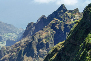
Santo Antão ist die wildeste und grünste Insel der Kap Verden. Ihr werdet die fantastische Bergwelt von Santo Antão lieben, wo sich inmitten hoch aufragender Klippen zauberhafte Ortschaften an abenteuerlichen Serpentinen-Straßen verbergen.
Santo Antão ist nach Santiago die zweitgrößte Insel der Kap Verden und liegt im Nordwesten des Archipels. Auf ihr haben sich scheinbar alle existierenden Landschaftsformen vereint, von schroffen Gipfeln und schwindelerregenden Schluchten bis zu felsigen Küsten und Sandstränden, von wüstenartigen Mondlandschaften bis zu fruchtbaren Tälern und tropischer Vielfalt.
Inhaltsverzeichnis
Bilder: Insel Santo Antão, Kap Verde

Fotogalerie: Insel Santo Antão, Kap Verde
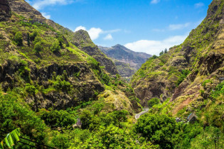
Santo Antão ist perfekt für Bergfexe – voll steiler Klippen, schwindelerregender Bergstraßen, fantastischer Aussichtspunkte und gut ausgebauter Wanderwege inmitten prachtvoller Landschaft. Das beste Beispiel dafür ist das atemberaubende Ribeira Fonteinhas.
Die Wanderwege auf Santo Antão sind übrigens vom feinsten. Da auch die Einheimischen auf ihnen jeden Tag enorme Strecken zurücklegen, sind sie optimal instand gehalten. Und bitte nicht frustrieren lassen, wenn ein Schulkind in Flip Flops bergauf zweimal so schnell unterwegs ist, wie so mancher Europäer in seinen sündteuren Bergschuhen!
Die Bevölkerung von Santo Antão lebt mittlerweile zum Großteil in den Städten, hat jedoch in seinem Herzen die Beständigkeit und Schwermut eines typischen Bergvolkes behalten. Ihre raue Melancholie bringen sie unter anderem im Colá, dem heimischen Volkstanz, zum Ausdruck.
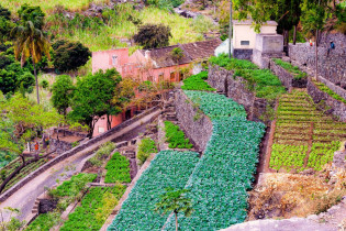
Landwirtschaft auf Santo Antão
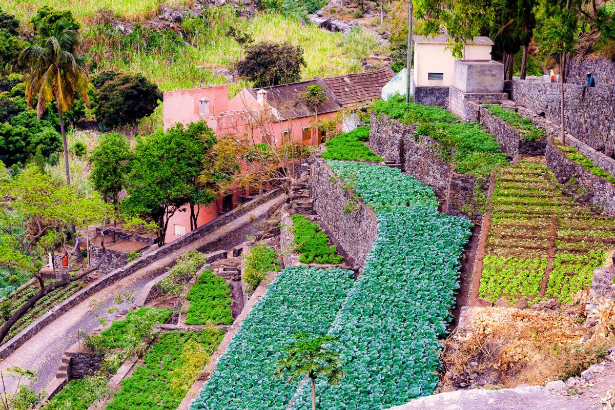
Im Süden und Westen präsentiert sich Santo Antão eher trostlos und wüstenhaft, auf der anderen Seite der Insel herrscht jedoch tropisches Klima, welches eine nahezu verschwenderische Vegetation gedeihen lässt. Fichten, Kiefern, Akazien, Affenbrotbäume und Drachenbäume recken ihre Wipfel ebenso in den Himmel, wie zahlreiche Obstbäume, an deren Ästen Mangos, Orangen, Feigen, Zitronen, Papayas, Datteln und Kokosnüsse wachsen.
Die fruchtbare Erde, die teilweise von der beigemischten Lava pechschwarz ist, wird trotz des geringen Niederschlags auch für die Landwirtschaft genutzt. Und so werden auf mühsam angelegten Terrassenfeldern an den Berghängen Kaffee, Ananas, Mais und Maniok angebaut.
Tipp: Im November/Dezember, nach der Regenzeit, zeigt sich Santo Antão von seiner grünsten Seite, dicht bedeckt vom blühenden Zuckerrohr. Dieses wird übrigens im März geerntet und kurz darauf gibt es frischen Grogue zu verkosten.
Porto Novo
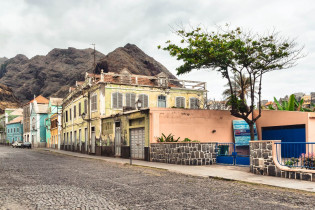
Porto Novo befindet sich im Südosten, wo der allgegenwärtige Wind den Staub Afrikas an die Küste weht, und gilt für Besucher als Eintrittstor auf die Insel. Nach Ribeira Grande ist Porto Novo die zweitgrößte Stadt auf der Insel Santo Antão und war einst ein bedeutender Hafen der Kap Verden.
Auf den lebhaften Märkten werden fangfrischer Fisch, Ziegenkäse und der traditionell kapverdische Grogue angeboten. Am Hafen herrscht mit Fähren und Fischerbooten ständiges Kommen und Gehen.
Die Hauptstraße wird von historischen Herrschaftshäusern gesäumt und wie in jeder Stadt darf auch hier die obligatorische Kirche nicht fehlen. Die Kolonialbauten werden mit dem Wachstum von Porto Novo zunehmend durch Betonbauten verdrängt. Die meisten Reisenden kommen in Porto Novo an und verlassen es gleich wieder, nur wenige wagen sich auf Wanderungen durch die staubige Hitze auf der westlichen Hochebene.
Abenteuerreise von Porto Novo nach Ribeira Grande
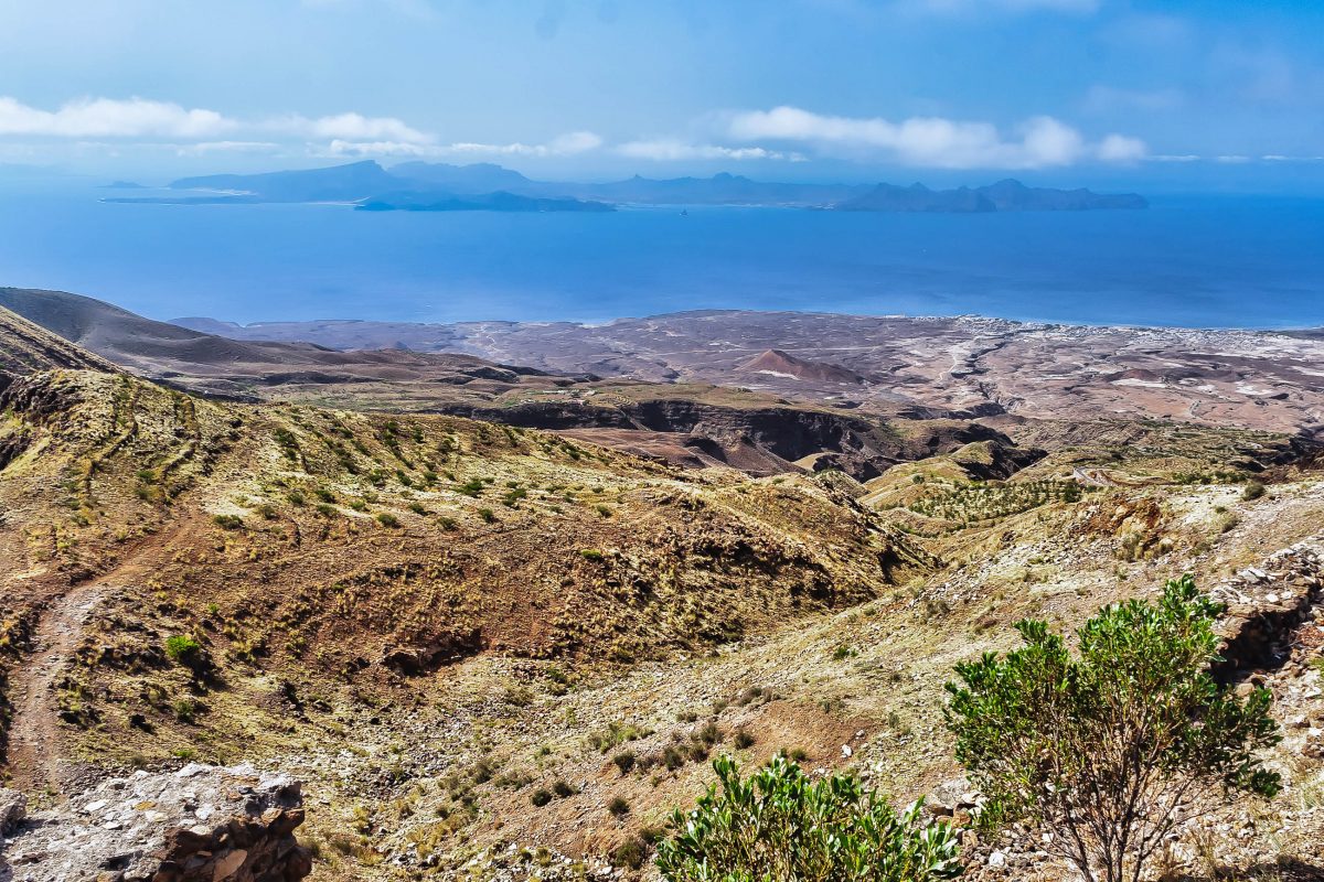
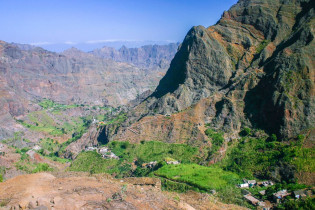
Wer Zeit hat und die Gegensätze auf Santo Antão in vollem Umfang erleben möchte, sollte die Reise von Porto Novo nach Ribeira Grande anstatt auf der langweiligen Asphaltstraße auf der alten kopfsteingepflasterten Straße antreten. Die von steilen Felskegeln gesäumte Straße führt bis zum Vulkan Cova de Paúl, der seinen Krater an die 1.000 Meter über den Meeresspiegel reckt.
Tipp: Wer diese einmalige Strecke mit dem Taxi oder dem Sammeltaxi zurücklegen möchte, muss den Taxifahrer extra darauf hinweisen, sonst ist man im Nullkommanichts über die Asphaltstraße ans Ziel gebracht.
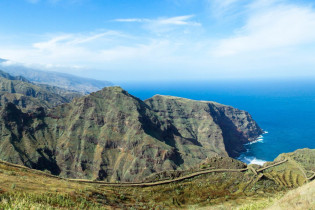
Inmitten von zerklüfteten Felsen öffnet sich ein atemberaubender Panoramablick über das dahinter liegende Tal Ribeira do Paúl und die Nordküste von Santo Antão. Bei klarem Wetter kann man in der Ferne sogar den Monte Verde auf der Nachbarinsel São Vicente erkennen.
An die Flanken des Berges schmiegt sich das Dörfchen Corda, das scheinbar aus dem Vulkan zu wachsen scheint. Hat man dieses passiert, ist der weitere Weg nichts für schwache Nerven! Die Straße windet sich entlang eines Bergrückens, an dem es rechts und links nahezu senkrecht in die Tiefe geht.
Vila das Pombas und Ribeira do Paúl
Das Küstendorf Vila das Pombas liegt in einer geschützten Bucht etwa 10 Kilometer östlich von Ribeira Grande. Das Örtchen verbreitet mit der gemütlichen Strandpromenade, seinen pastellfarbenen Häusern, der kleinen Kirche und dem himmelblauen Rathaus einen zauberhaften Charme, der ihm einen Platz auf unserer Liste der Top 10 Sehenswürdigkeiten der Kap Verden beschert hat.
Folgt man der Küstenstraße weiter nördlich, gelangt man nach Sinagoga, wo sich einst die jüdische Bevölkerung von Santo Antão angesiedelt hat.
Nach Süden führt die Küstenstraße durch die üppige Landschaft des Ribeira da Janela. Neben der dichten Vegetation wartet im Ribeira da Janela eine Grogue-Destillerie und der Leuchtturm von Janela aus dem Jahr 1886 auf den interessierten Besucher. In Portinha da Janela lohnt sich ein kleiner Abstecher etwa 500m das Tal hinauf. Dort sind auf einem freistehenden Stein Felsritzungen zu entdecken.
Wanderungen mit karibischem Flair
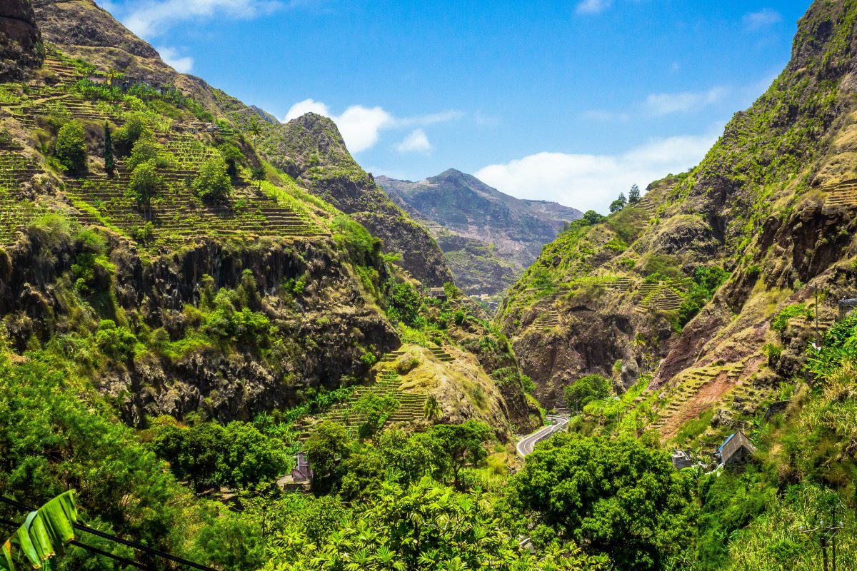
Vila das Pombas gilt als Eintrittstor in das zerklüftete und vegetationsreiche Tal „Ribeira do Paúl“ im gleichnamigen Bezirk.
Hinter Vila das Pombas erstreckt sich das wildromantische Tal bis zum Krater des Coya do Paúl. Kokospalmen und Zuckerrohrplantagen schaffen eine Atmosphäre wie in der Karibik. Etwa in seiner Mitte beherbergt das Ribeira do Paúl das zauberhafte Nest Passagem. Besucher wissen das Örtchen aufgrund seines wunderschönen Terrassen-Schwimmbades in absolut traumhafter Kulisse zu schätzen.
Etwa 2 Kilometer von Passagem entfernt liegt Aldeia Manga. Die aus einem Haus aus Stein und mehreren Lehmziegelbauten bestehende Pension ist der optimale Ausgangspunkt für Wanderungen in die Umgebung.
Für hungrige Wanderer und vor allem für deutschsprachige Reisende zu empfehlen ist das Restaurant von Alfred. Das nette Lokal des gebürtigen Österreichers befindet sich etwa 2 Kilometer oberhalb der Aldeia Manga in Cha de João Vaz und versorgt seine Gäste mit hausgemachten Produkten. Vor allem seine ausgezeichneten Liköre und Grogue-Varianten sind eine Kostprobe wert.
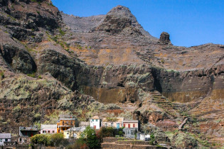
Ribeira Grande

Die Hauptstadt von Sao Antão liegt im gleichnamigen Tal Ribeira Grande im Nordosten der Insel. Touristisch noch kaum erschlossen verbreiten die Bewohner der Hauptstadt in den verwinkelten Gassen und Treppen von Ribeira Grande lebhafte Stimmung.
Bank, Postamt, die wichtigsten Ämter und eine Vielzahl von Kneipen ziehen viele Einheimische nach Ribeira Grande. Die wenigen Hotels werden von kleineren Pensionen ergänzt, die sich durch guten Service und Gastfreundlichkeit auszeichnen.
Das Zentrum von Ribeira Grande bildet der Praça mit der gleichnamigen Igreja Nossa Senhora do Rosário, eine wuchtige Kirche mit vergleichsweise winzigem Glockenturm. Ganz in der Nähe befinden sich ein Internet-Café, und der Stadtmarkt Mercado Municipal, an dem vor allem Lebensmittel feilgeboten werden. Im Norden von Ribeira Grande ist ein eigener Textilmarkt zu finden.
Chã de Igreja und Ribeira Fonteinhas

Im Westen des Tals von Ribeira Grande liegt in einer etwa 50m tiefen Schlucht die zauberhafte Siedlung Chã de Igreja. Am Dorfplatz befindet sich eine schmucke schneeweiße Kirche. Der zentrale Platz wird von netten Häusern umgeben, die des Öfteren von ihren Bewohnern mit prachtvollem Blumenschmuck verziert werden.
Der Weg von Chã de Igreja nach Ponta do Sol ist absolut atemberaubend. Entlang von Steilhängen und zerklüfteten Schluchten erreicht man auf dieser Strecke den Ort Fontainhas, der aus den steilen Bergflanken heraus zu wachsen scheint. Bis hierher kann man den Weg mit dem Auto zurücklegen, zu Fuß dauert die Wanderung etwa drei Stunden
Spätestens in Fonteinhas ist es allerdings vorbei mit dem fahrbaren Untersatz und man kann sich auf eine weitere zweistündige Wanderung bis an die Küste aufmachen. Auf Schusters Rappen passiert man die unberührten Fischerdörfer Corvo und Forminguinhas und gelangt schließlich bis nach Cruzinha da Graça, welches malerisch auf einer Landzunge gelegen ins Meer ragt.
Ponta do Sol
Folgt man der Straße durch das Ribeira Fonteinhas weiter nach Nordwesten gelangt man nach Ponta do Sol an der nördlichsten Spitze der Insel. Ponta do Sol wird immer wieder als der schönste Ort von Santo Antão genannt. An der idyllischen Landzunge liegen farbenfrohe Fischerboote, Restaurants und Bars locken mit leckeren Gerüchen, Hotels und kleine Pensionen heißen gerne Gäste willkommen.
Das Zentrum bildet auch hier der Dorfplatz mit einer weißen Kirche, der vom prachtvollen Kolonialbau des Rathauses dominiert wird. Ebenfalls prächtig anzusehen ist die Präsidentenvilla in Ponta do Sol, der Zweitwohnsitz des Präsidenten der Kap Verden, mit ihrem zugehörigen fantastischen Garten.
Unterwegs an die Westküste von Santo Antão
Ebenfalls von Porto Novo aus führt eine Straße in das Ribeira das Patas im Zentrum der Insel. Es beeindruckt vor allem durch seine senkrecht in den Himmel ragenden Felsen. Weiter geht es nach Westen zum Tope de Coroa, dem mit 1980 Metern höchsten Berg von Santo Antão.
Auf dieser Strecke, die nach Ponte Sul etwas holprig ist und am besten mit dem Geländewagen befahren wird, ist das nächste Ziel der Ort Tarrafal de Monte Trigo an der Westküste der Insel (nicht zu verwechseln mit Tarrafal im Norden der Insel Santiago oder auf São Nicolau).
Tarrafal de Monte Trigo
Nach der mühsamen Anfahrt ist Tarrafal de Monte Trigo eine wunderbare Oase der Ruhe und Entspannung. Der pechschwarze Lavastrand in der geschützten Bucht von Tarrafal de Monte Trigo erstreckt sich über mehrere Kilometer und gilt als der schönste Strand von Santo Antão. Hinter Tarrafal de Monte Trigo ragen gewaltige Felsklippen in den azurblauen Himmel.
Wer in dieser idyllischen Oase übernachten möchte, wird vom „Mar Tranquilidade“ willkommen geheißen, einer netten Natursteinanlage. Die Bungalows werden von Susi und Frank, einem deutsch-amerikanischen Pärchen, unterhalten. Sie kamen einst mit dem Segelboot nach Tarrafal de Monte Trigo und wollten nie wieder weg. Irgendwie nachvollziehbar.


